|
Mon River Trail (Star City to State line) |
one moment while we fetch a trail picture
|
|
|
Mon River Trail (Star City to State line) |
one moment while we fetch a trail picture
|

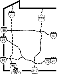
The Mon River Trail runs for 29+ miles south from the PA/WV state line along the east bank of the Monongahela River. The trail can be divided into three sections based on changes in trail surface. Starting at the PA/WV line the Mon River Trail goes south for 5.9 miles on crushed limestone. Just north of Star City the surface becomes asphalt for 5.6 miles through Morgantown; this section is named for Gov. Gasper Caperton. At the <<southern edge of Morgantown (MPXX.X)>>the surface reverts to crushed limestone, the name reverts to Mon River Trail and the trail continues another 17.3 miles to Prickett’s Fort State Park. The trail runs on a bench with a cliff on one side and the river on the other. Mile post zero is at the state line.
The Mon River Trail starts in the woods at the PA/WV state line. Here it connect seamlessly with the Sheepskin Trail. (Page WS23). The current access to MP0 of the Mon River Trail is via the Sheepskin Trail in Point Marion. The scenery is largely wooded, varied by a couple of small summer camps/villages between the trail and the river, and by large industrial plants across the river – a power plant at MP1 and coal loading plants at MP3 and MP5. <<At MP5.xxx>> there is a side trail (Collins Ferry Connector) that leads up the hill to several research facilities and the suburbs of Morgantown. Between MP5 and MP6 the hillside becomes more cliff like and there are a couple of impressive waterfalls. Just before MP5.95 the trail becomes paved. At the Star City trailhead, MP6.5, there is an elaborate play area near the rest rooms. Just past Star City one passes by the obligatory sewer plant. Between MP7.2 and MP8.1 is the West Virginia University Arboretum. Several hiking trails (no bikes allowed) and one service road (very steep bikeable gravel) lead up into the Arboretum.Past the Arboretum (MP8.5) are the outskirts of Morgantown and parts of West Virginia University with its monorail system. The trail runs along the edge of downtown Morgantown. The bus station and Hazel Ruby McQuain Riverfront Park are at MP13.8. Here, just before an impressive railroad bridge, Deckers Creek Trail (page SW-<<decker cross ref>>) splits off to the left. On the other side of the bridge several restaurants are right along the trail. Shortly thereafter downtown buildings turn into industrial buildings with the Morgantown Lock and Dam at MP10.6. At MP11.5 development disappears at the Greer Mine Silo and Conveyor. The trail turns from asphalt to crushed limestone and becomes gloriously isolated on a bench at the base of a bluff as it heads for Prickett’s Fort.
The isolation is interrupted at MP13.5 for Twin Spruce Marina at Uffington, WV. At MP16.7 is Hildebrad Lock and Dam with a slight rise in the trail. A few houses and summer camp are at MP18.5 at Little Falls. MP<<24.2 Opekiska>>, <<26.3 Jordan>>, <<27.9 Catawba>>
Note: Morgantown requires all bicycle riders to wear helmets. They enforce this rule with tickets.
| Location | Point Marlon to Prickett’s Fort State Park in Monongalia and Marion Counties WV | ||
| Trailheads | Star City, Morgantown, Uffington, Prickett’s Fort State Park | ||
| Length, Surface | 0.7 in planing, 5.6 paved, 23.5 miles crushed limestone | ||
| Character | Uncrowded, urban riverfront, sunny, flat | ||
| Usage restrictions | No motorized vehicles | ||
| Amenities | Bike shop, food, lodging | ||
| Driving time from Pittsburgh | 1 hours 14 minutes |